
Madagascar is grappling with a growing humanitarian emergency after two powerful cyclones struck the island nation within three weeks, leaving widespread destruction and pushing hundreds of thousands of people into urgent need of assistance.
The United Nations World Food Programme (WFP) says around 400,000 people are now facing acute humanitarian needs following the storms, which damaged homes, infrastructure and vital services across several regions.
Powerful Cyclone Hits Key Coastal City
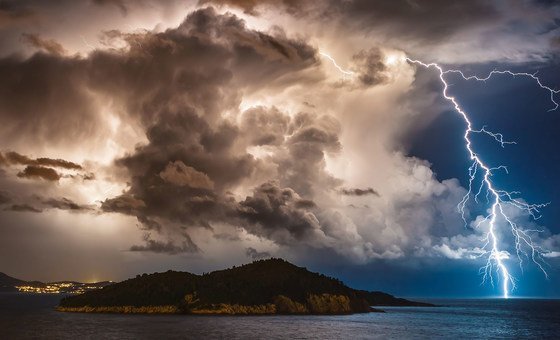
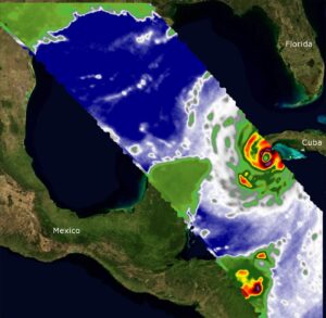
Cyclone Gezani made landfall on Tuesday evening near the port city of Toamasina, also known as Tamatave, Madagascar’s second largest urban centre. The storm brought powerful winds reaching up to 250 kilometres per hour, leaving extensive destruction in its wake.
Tania Goossens, WFP’s country director in Madagascar, described the devastation after returning from a field visit to the city.
“The scale of the destruction is really overwhelming,” she told reporters during a briefing from the capital, Antananarivo.
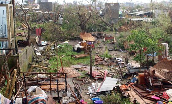
Local authorities estimate that roughly 80 percent of Toamasina has sustained damage. Essential services have also been severely disrupted, with electricity functioning at only a fraction of normal capacity.
“It’s running on roughly five percent electricity at the moment,” Goossens said, adding that large areas remain without water supply. Even the WFP’s warehouse and office in the city were completely destroyed by the cyclone.
Casualties And Widespread Damage
Initial assessments indicate that at least 38 people have died and more than 370 others have been injured as a result of the storm.
Beyond the human toll, the cyclone has caused extensive damage to homes, businesses, schools and healthcare facilities. The city’s main hospital was among the structures affected.
Goossens said many families have been forced to abandon their homes after roofs were ripped off buildings or entire structures collapsed under the force of the winds.
During her visit to the disaster zone, she saw residents attempting to recover what little remained of their belongings from the wreckage.
“Many are spending the night in homes where the roofs have been torn off,” she said.
Streets throughout the city remain blocked by uprooted trees and debris, making movement difficult. Fuel shortages are also complicating relief efforts.
Families Struggle To Find Food And Shelter
The storm has left thousands of residents uncertain about how they will secure food and shelter in the coming days.
According to WFP officials, many families have lost nearly all of their possessions. Some are sheltering in damaged homes while others have moved to temporary sites with limited facilities.
“Families are telling us that they have lost everything,” Goossens said, warning that access to basic necessities remains a major concern.
Humanitarian agencies are particularly worried about deteriorating water, sanitation and hygiene conditions. Damaged infrastructure and shortages of clean water could increase the risk of disease outbreaks in affected communities.
Aid workers are also monitoring rising protection risks for vulnerable groups, including women, children, elderly people and individuals with disabilities.
Aid Efforts Underway Amid Funding Shortfall
Before the storm struck, the WFP and partner organisations had already begun distributing cash assistance to vulnerable households so they could purchase food and prepare for the cyclone.
Now, the agency is deploying its remaining emergency food supplies to assist affected communities, working closely with Madagascar’s national disaster response teams.
However, Goossens warned that the scale of the crisis is exceeding the resources currently available.
The country was already facing serious food insecurity even before the cyclones hit. According to the latest data from the Integrated Food Security Phase Classification (IPC), about 1.57 million people across Madagascar were experiencing food shortages, with around 84,000 facing emergency levels of hunger.
Concern As Cyclone Season Begins
The humanitarian challenge is compounded by the timing of the disaster. Madagascar is currently entering the peak of its lean season, the period before harvests when food supplies are typically at their lowest.
At the same time, funding shortages are threatening to limit the response.
The WFP estimates that it faces an $18 million funding gap over the next six months to support both lean season assistance and cyclone relief operations.
“We will need sustained support over the coming months to help people recover, rebuild and strengthen their resilience against further shocks,” Goossens said.
With the cyclone season only just beginning, aid agencies fear that additional storms could further strain already fragile communities across the island nation.