Tsunami alert highlights worth of global early warning system

While the UN-backed International Atomic Energy Agency (IAEA) reported 
that there had been no damage to Japan’s nuclear facilities after an 8.8 magnitude quake was recorded off Russia’s Kamchatka Peninsula, coastal communities have been taking no chances and evacuating to higher ground or moving further inland.

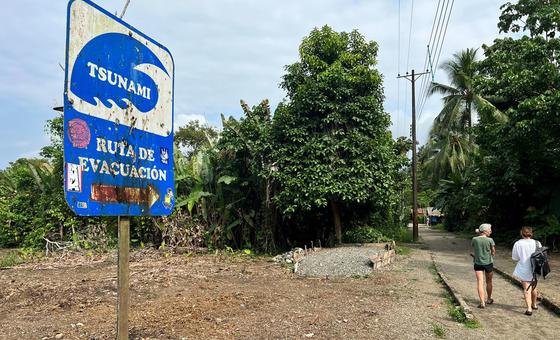
Alerts were sent out within a few minutes of the Russia quake, the UN Office for Disaster Risk Reduction (UNDRR) confirmed. Although the authorities have now downgraded the threat across Japan as waves of 1.3 metres (4ft 2in) have been recorded, the advice is for people to stay in shelters until the danger diminishes from continuing sea surges.

“It is very complex; we are observing the tsunami data in real time, so we need people to stay at the shelter until the tsunami is completed,” said tsunami engineer Professor Fumihiko Imamura from Tohoku University.

Deadly legacy

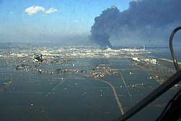
In the Asian island nation, memories are still raw from the 11 March 2011 Tohoku earthquake and tsunami which killed more than 18,000 people.

Just last year, the 7.6 magnitude Noto quake left approximately 500 dead and damaged 150,000 homes.

The disaster also caused a major accident at the Fukushima Daiichi Nuclear Power Plant, forcing tens of thousands of people from their homes. 

Today’s developments come amid reports that the latest earthquake was among the 10 most powerful ever recorded, hence why the authorities are monitoring its impact so closely.

So far, alerts have been triggered off the west coast of the United States, in South America from Chile to Mexico and from Papua New Guinea to Vanuatu in the Pacific. 

A 8.8 magnitude earthquake is a very large earthquake,” explained Kamal Kishore, Special Representative of the UN Secretary-General for Disaster Risk Reduction. 

“As you go from magnitude eight to nine, or seven to eight, at every step the strength of the earthquake increases exponentially. So, an earthquake which is magnitude eight as opposed to seven would be 30 times bigger.” 

Faster than a jet liner

Speaking to UN News, Mr. Kishore highlighted the huge distances tsunamis can cover, picking up enormous energy they then dump on coastal communities. 

Their progress can be as fast as a passenger jet and can be tracked by deep sea pressure change sensors, or tsunameters, that are connected to surface buoys which relay information in real time to satellites. This data is then modelled by national weather centres, influencing whether alerts are issued.

“It’s a real threat because the tsunamis travel really fast from one coast to the other,” continued Mr. Kishore. “The Indian Ocean tsunami of 2004 was one of the most devastating in our memory, which travelled from all the way from the coast of Indonesia to the Sri Lankan shores within a little over an hour.”

Lessons learned

In addition to the coordination role of UNDRR in the global early warning system, other UN entities also closely involved include the World Meteorological Organization (WMO) and the Intergovernmental Oceanographic Commission of the UN agency for Education, Science and Culture (UNESCO-IOC).  

The IOC’s role is critical in making sure that countries that use tsunami-tracking instrumentation follow the same standard. 

These efforts are in line with the UN Secretary-General’s Early Warnings for All initiative to ensure that everyone on Earth is protected from hazardous weather, water or climate events through lifesaving early warning systems.

Today, one in three people – and mainly in least developed countries and Small Island Developing States – lacks access to adequate multi-hazard early warning systems.

“Tsunami prevention really highlights how important it is to have multilateral action” such as sharing data to run the algorithms behind wave modelling systems, insisted the UN’s Mr. Kishore. 

“There are countries which are separated by thousands of kilometres of ocean, but they are affected by the same hazard,” he continued. 

“If you do not share information on observing these hazards, not just in the location where they have occurred, but on what is happening in the intermediate locations in the ocean…we will not be able to warn our citizens.”  

Source link

Japan’s Tonga volcano eruption nine times taller than 2011 tsunami

New research reveals more about the magnitude of January eruption, as researchers call for better preparedness.

  • The eruption of the Hunga Tonga-Hunga Ha’apai volcano in January created an initial wave 90 metres high – almost the height of the Statue of Liberty (93m)
  • University of Bath tsunami expert calls for better warning systems to detect volcanic eruptions, saying systems are 30 years behind comparable earthquake detection tools

The initial tsunami wave created by the eruption of the underwater Hunga Tonga Ha’apai volcano in Tonga in January 2022 reached 90 metres in height, around nine times taller than that from the highly destructive 2011 Japan tsunami, new research has found.

An international research team says the eruption should serve as a wake-up call for international groups looking to protect people from similar events in future, claiming that detection and monitoring systems for volcano-based tsunamis are ’30 years behind’ comparable tools used to detect earthquake-based events.

Tsunami/en.wikipedia.org

Dr Mohammad Heidarzadeh, Secretary-General of the International Tsunami Commission and a senior lecturer in the University of Bath’s Department of Architecture & Civil Engineering, authored the research alongside colleagues based in Japan, New Zealand, the UK and Croatia.

By comparison, the largest tsunami waves due to earthquakes before the Tonga event were recorded following the Tōhoku earthquake near Japan in 2011 and the 1960 Chilean earthquake, reached 10 metres in initial height. Those were more destructive as they happened closer to land, with waves that were wider.

Dr Heidarzadeh says the Tonga tsunami should serve as a wake-up call for more preparedness and understanding of the causes and signs of tsunamis cause by volcanic eruptions. He says: “The Tongan tsunami tragically killed five people and caused large scale destruction, but its effects could have been even greater had the volcano been located closer to human communities. The volcano is located approximately 70 km from the Tongan capital Nuku’alofa – this distance significantly minimized its destructive power.

“This was a gigantic, unique event and one that highlights that internationally we must invest in improving systems to detect volcanic tsunamis as these are currently around 30 years behind the systems we used to monitor for earthquakes. We are under-prepared for volcanic tsunamis.”

The research was carried out by analysing ocean observation data recordings of atmospheric pressure changes and sea level oscillations, in combination with computer simulations validated with real-world data.

The research team found that the tsunami was unique as the waves were created not only by the water displaced by the volcano’s eruption, but also by huge atmospheric pressure waves, which circled around the globe multiple times. This ‘dual mechanism’ created a two-part tsunami – where initial ocean waves created by the atmospheric pressure waves were followed more than one hour later by a second surge created by the eruption’s water displacement.

The eruption created an initial wave 90 metres high/University of Bath

This combination meant tsunami warning centres did not detect the initial wave as they are programmed to detect tsunamis based on water displacements rather than atmospheric pressure waves.

The research team also found that the January event was among very few tsunamis powerful enough to travel around the globe – it was recorded in all world’s oceans and large seas from Japan and the United States’ western seaboard in the North Pacific Ocean to the coasts within the Mediterranean Sea.

The paper, co-authored by colleagues from New Zealand’s GNS Science, the Association for the Development of Earthquake Prediction in Japan, the University of Split in Croatia and at London’s Brunel University, was published this week in Ocean Engineering.

Dr Aditya Gusman, Tsunami Modeller at the New Zealand-based geoscience service, says: “The 2018 Anak Krakatau volcano and 2022 Hunga Tonga-Hunga Ha’apai volcano eruptions clearly showed us that coastal areas surrounding volcano islands are at risk of being hit by destructive tsunamis. Although it may be preferable to have low-lying coastal areas completely clear from residential buildings, such a policy may not be practical for some places as volcanic tsunamis can be considered infrequent events.”

Co-author Dr Jadranka Šepić, from the University of Split, Croatia, adds: “What is important is to have efficient warning systems, which include both real-time warnings and education on what to do in a case of a tsunami or warning – such systems save lives. In addition, at volcanic areas, monitoring of volcanic activity should be organized, and more high-quality research into volcanic eruptions and areas at hazard is always a good idea.”

Separate research led by the University of Bath atmospheric physicist Dr Corwin Wright published in June found that the Tonga eruption triggered atmospheric gravity waves that reached the edge of space.