

According to the UN relief coordination office, OCHA, 998,918 people across all 25 districts have now been affected, with 212 deaths reported and 218 people missing. More than 180,000 people from over 51,000 families are sheltering in 1,094 government-run safety centres as search and rescue efforts continue.
Cyclone Ditwah made landfall on 28 November before moving back over the Bay of Bengal, triggering some of the most severe flooding Sri Lanka has seen since the early 2000s.
The hardest-hit districts include Gampaha, Colombo, Puttalam and Mannar, as well as Trincomalee and Batticaloa, while deadly landslides in the central hill country have devastated Kandy, Badulla and Matale.
Homes destroyed, infrastructure shattered
Initial assessments indicate that more than 15,000 homes have been destroyed. Over 200 roads remain impassable, at least 10 bridges have been damaged, and sections of the rail network and national power grid affected.
Flooding along the Kelani River, which runs through Colombo and surrounding low-lying areas, continues to hamper access and disrupt information flow from affected communities, complicating rescue and relief operations.
Severe disruption to electricity, mobile and communications, and transport networks are reported in northern districts such as Jaffna, with entire villages isolated.
Access to clean water also remains a major concern, with several areas reporting little or no supply.
Health system under strain, food insecurity looms
Sri Lanka’s already fragile health system is under severe pressure, OCHA said. Several district hospitals remain flooded and are receiving only limited supplies, with critically ill patients being airlifted to functioning facilities.
Response is further hindered by recurring landslides and the breach of multiple tank bunds (embankments or barriers), including at Mavilaaru, heightening risks in Trincomalee and Batticaloa.
Authorities have also warned of rising food insecurity, as submerged farmland, damaged storage facilities and severed supply routes threaten shortages and price increases in the weeks ahead.
The World Health Organization (WHO) warned that floods significantly raise the risk of vector-borne, food-borne and water-borne diseases, urging communities to prevent mosquito bites, ensure food safety and use safe drinking water wherever possible.

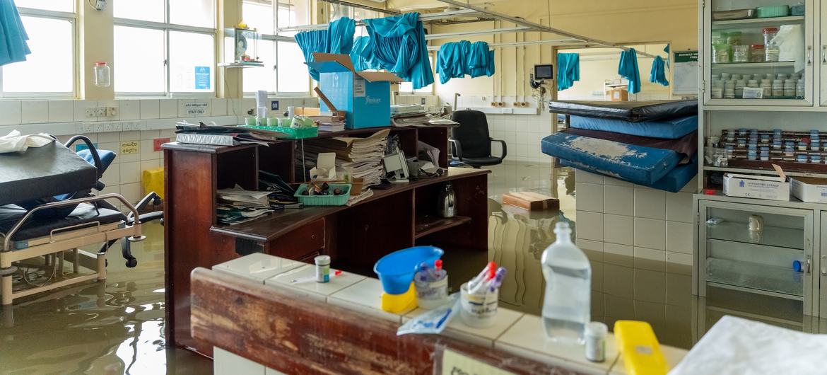
Floodwaters have entered several hospitals across Sri Lanka, further straining the health system.
UN mobilises coordinated response
The United Nations in Sri Lanka activated its emergency coordination system on Sunday to scale up a unified response with government agencies and humanitarian organizations.
Sector coordination has been set up across food security, health, water and sanitation (WASH), education, protection, shelter and early recovery, while a multi-sector needs assessment is under way with disaster management authorities to identify the most urgent gaps.
“The UN in Sri Lanka is mobilising its teams across the system to support national rescue and early recovery efforts, in coordination with authorities. We stand in solidarity with all affected communities,” said UN Resident Coordinator Marc-André Franche.
Despite access challenges, the UN Children’s Fund (UNICEF) has delivered portable water to 25 safety centres in Badulla in the central hills, which had been cut off from the rest of the country by floods and infrastructure damage.
To support government-led efforts, India and Pakistan have deployed emergency teams to work alongside Sri Lanka’s armed forces in the worst-hit districts.
Meanwhile, in the wider Asian region
Severe monsoon flooding continues across Thailand and Malaysia, affecting more than two million people in southern Thailand alone and displacing nearly 25,000 people in Malaysia, according to OCHA. People have been evacuated in several hard-hit Thai provinces, while the rainfall is expected to ease in coming days.
In Indonesia, media reports cite at least 440 deaths from floods and landslides, with more than 400 people missing, particularly in parts of Sumatra, where thousands remain stranded without access to food and water.