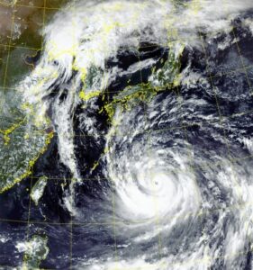
Sep 19 (IANS) At least two people were killed in Japan and some nine million others asked to evacuate from their homes after super typhoon Nanmadol, deemed to be one of the worst, made landfall in the region of Kyushu, bringing heavy rain and gales, local media reported on Monday.
In Fukuoka prefecture, a man who was believed to be on his way to find shelter from the typhoon was found collapsed and later confirmed dead, reports Xinhua news agency.
Another man was declared dead after being pulled out of a car submerged in a flooded farmland in Miyazaki prefecture, according to local authorities.
According to a Miyazaki prefectural official, a man in his 40s was reported missing after his cabin was destroyed by a landslide.
Typhoon/Ians
The 14th typhoon of the year was moving near Hagi, Yamaguchi prefecture on Monday afternoon, at a speed of some 20 km per hour.
It had an atmospheric pressure of 975 hectopascals at its centre, packing winds up to 108 kph with maximum gusts of 162 kph.
More than 70 people were injured amid the extreme weather, with bullet trains suspended in Kyushu on Monday and around 600 flights cancelled by the country’s two main airlines ANA and Japan Airlines, the local media reports said.
The typhoon is expected to travel across Japan’s largest island, Honshu through Tuesday, with the Japan Meteorological Agency continuing to issue warnings for strong winds, high tides and mudslides.
Typhoon/Ians
Tens of thousands of people spent Sunday night in emergency shelters, and almost 350,000 homes are without power.
Prime Minister Fumio Kishida has delayed a visit to New York, where he is due to give speech at the UN General Assembly, until Tuesday, to monitor the impact of the storm.
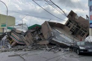
Sep 18 (IANS):A 6.9-magnitude earthquake hit eastern Taiwan’s Hualien County at 2:44 p.m. Sunday Beijing Time, according to the China Earthquake Networks Center (CENC).
The epicenter was monitored at 23.15 degrees north latitude and 121.30 degrees east longitude, at a depth of 10 km, Xinhua news agency reported quoting the CENC.
Strong tremor was felt across the island. A three-storey building in Hualien, whose ground floor was a convenience store, collapsed, trapping some people, according to local media.
Earthquake/Ians
A train carriage was turned over by a fallen rain shed in a railway station in Hualien, but all passengers left safe. A bridge fracture left two people injured. The rescue work is underway, according to local media.
Indian Met Department has issued an alert to Tamil Nadu, Kerala, Karnataka, Goa, Maharasthra and the Lakshadweep over the cyclone ‘Sagar’, which is building up over the Arabian Sea with potential to hit the coastal region of northern Indian Ocean on Saturday.
Formerly known as 01A, Tropical Cyclone Sagar, quickly formed in the Indian Ocean and strengthened into a tropical storm on May 16 at 3:35 a.m. IST as shown in the resolution imaging captured by the spectroradiometer aboard NASA’s Aqua satellite.
It showed thunderstorms at minus 80 degrees Celsius, which means very strong storms with a potential for heavy rainfall in the Arabian Sea with maximum sustained winds near 46 miles per hour (40 knots). Located near 13.0 degrees north latitude and 48.6 degrees east longitude, or approximately 229 nautical miles east of Aden, Yemen.
When captured NASA-NOAA’s Suomi NPP satellite appeared more organized and has been strengthening since May 17. On Friday, May 18 the Visible Infrared Imaging Radiometer Suite (VIIRS) instrument aboard NASA-NOAA’s Suomi NPP satellite captured a true-color image of Tropical Cyclone Sagar showing the center above the Gulf of Aden, affecting Yemen and Somalia.
At 1:30 p.m IST, the Tropical Cyclone Sagar was centered near 11.6 degrees north latitude and 45.9 degrees east longitude, approximately 89 nautical miles southeast of Aden, Yemen, registering maximum sustained winds up at 69 mph (50 knots/111 kph). Currently, Sagar is moving to the west-southwest at 6.9 mph (6 knots/11.1 kph).
Sagar is likely to threaten Yemen, Somalia and Djibouti with waves as high as 17 feet, before hitting the Indian west coast on Saturday. The Indian Meteorological Department (IMD) has issued an advisory that said: “Strong winds reaching upto 75-85 kmph and 95 kmph covering the Gulf of Aden and adjoining south-western Arabian Sea area are very likely duting the next 12 hours. It may then gradually decrease ato 65-75 kmph during the next 12 hours.”
Fishermen are advised not to venture into the high seas of the Gulf of Aden or west-central and south-west Arabian Sea in the next 48 hours.
On April 24, NASA’s Aqua satellite captured a visible image of Tropical Cyclone Fakir, southeast of La Reunion Island. The image showed vertical wind shear was pushing the bulk of clouds southeast of the center of circulation.Credits: NASA/NRL
Tropical Cyclone Fakir tracked by NASA’s Aqua satellite, Heavy rains, tsunami-like waves likely on Indian coast of Andhra Pradesh and Odisha on Wednesday.
NASA’s Aqua satellite captured a visible image of Tropical Cyclone Fakir, southeast of La Reunion Island, that showed vertical wind shear affecting it in the Southern Indian Ocean.
The Joint Typhoon Warning Center or JTWC noted on Tuesday, April 24 at 11 a.m. EDT that Fakir’s center was located near 23.3 degrees south latitude and 57.5 degrees east longitude.
From the image taken at the location is approximately 162 nautical miles south of Port Louis, Mauritius, cyclone Fakir was seen moving to the south-southeast at 18 knots (20.7 mph/33.3 kph). Maximum sustained surface winds were estimated at 60 knots (69 mph /111 kph).
The Moderate Resolution Imaging Spectroradiometer or MODIS instrument aboard NASA’s Aqua satellite has captured a visible image of Fakir that showed a rapidly disintegrated system.
The image showed the cyclone elongated as the bulk of clouds and thunderstorms were being pushed to the southeast of the center, in an area of high vertical wind shear between 40 and 50 knots (46 to 57 mph/74 to 92 kph).
JTWC warned that “[Fakir] is forecast to continue deteriorating due to the severe vertical wind shear associated with the trough (elongated area of low pressure) approaching from the west and cooling sea surface temperatures along its forecast track to the southeast. The unfavorable environment will lead to dissipation by Thursday, April 26.”
The southwest Indian Ocean cyclone season that started on November 15, 2017 will last until April 30, 2018 and the major cyclone Fakir formed on Monday, April 23 near northeastern Madagascar as captured by the Global Precipitation Measurement mission or GPM core satellite looked at the storm’s rainfall rates.
On April 22, GPM showed that bands of extremely heavy rainfall were spiraling into the tropical low’s southeastern side. GPM’s radar (DPR Ku Band) showed that precipitation was falling at a rate of over 219 mm (8.6 inches) per hour in some of the strong convective storms that were moving toward Madagascar. GPM’s radar indicated that a few of the tallest intense convective storms were reaching heights of almost 16 km (9.9 miles).
Credits: NASA/JAXA, Hal Pierce
Fakir is expected to intensify as it moves toward the southeast and could be a significant tropical cyclone on Wednesday. Fakir will add woes to an already battered Madagascar by tropical cyclones Ava, Dumazile, and Eliakim.
The GPM core observatory satellite flew above the forming cyclone near northeastern Madagascar on April 22, 2018 and its Microwave Imager (GMI) and Dual Frequency Precipitation Radar (DPR) instruments revealed the locations of heavy rainfall linked with the forming Fakir cyclone.
GPM showed that bands of extremely heavy rainfall were spiraling into the southeastern side, precipitation was falling at a rate of over 219 mm (8.6 inches) per hour in some of the strong convective storms, seen moving toward Madagascar.
A 3-D view of precipitation in forming tropical cyclone Fakirwas simulated 3-D cross section generated at NASA’s Goddard Space Flight Center in Greenbelt, Maryland to show the heights of cloud tops and radar reflectivity values within the forming tropical cyclone.
GPM’s radar indicated some convective storms were reaching heights of almost 16 km (9.9 miles). On April 23, 2018 at 11 a.m. EDT, Fakir had maximum sustained winds near 40 knots (46 mph/74 kph). Fakir was centered near 6.5 degrees south latitude and 53.2 east longitude, about 313 nautical miles north-northwest of St Denis, la Reunion and seen moving southeastward to hit the Indian coast. The system is expected to peak in strength in one day, April 24.