2 dead, 9 mn people to evacuate after super typhoon hits Japan; Typhoon expected to travel across Honshu

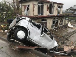
Sep 19 (IANS) At least two people were killed in Japan and some nine million others asked to evacuate from their homes after super typhoon Nanmadol, deemed to be one of the worst, made landfall in the region of Kyushu, bringing heavy rain and gales, local media reported on Monday.

In Fukuoka prefecture, a man who was believed to be on his way to find shelter from the typhoon was found collapsed and later confirmed dead, reports Xinhua news agency.

Another man was declared dead after being pulled out of a car submerged in a flooded farmland in Miyazaki prefecture, according to local authorities.

According to a Miyazaki prefectural official, a man in his 40s was reported missing after his cabin was destroyed by a landslide.

typhoon

Typhoon/Ians

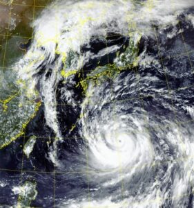
The 14th typhoon of the year was moving near Hagi, Yamaguchi prefecture on Monday afternoon, at a speed of some 20 km per hour.

It had an atmospheric pressure of 975 hectopascals at its centre, packing winds up to 108 kph with maximum gusts of 162 kph.

More than 70 people were injured amid the extreme weather, with bullet trains suspended in Kyushu on Monday and around 600 flights cancelled by the country’s two main airlines ANA and Japan Airlines, the local media reports said.

The typhoon is expected to travel across Japan’s largest island, Honshu through Tuesday, with the Japan Meteorological Agency continuing to issue warnings for strong winds, high tides and mudslides.

Typhoon/Ians

Tens of thousands of people spent Sunday night in emergency shelters, and almost 350,000 homes are without power.

Prime Minister Fumio Kishida has delayed a visit to New York, where he is due to give speech at the UN General Assembly, until Tuesday, to monitor the impact of the storm.

NASA sees wide-eyed Typhoon Noru headed for landfall in Kyushu, Japan

Typhoon Noru was churning just south of the southwestern-most island of Japan when NASA’s Terra satellite captured an image of the storm with an eye over 35 miles wide. The Joint Typhoon Warning Center expects Noru to make landfall in Kyushu by August 6.

On August 4, 2017 at 0220 UTC (Aug. 3 at 10:20 p.m. EDT), NASA’s Terra satellite passed over the Northwestern Pacific Ocean and the Moderate Resolution Imaging Spectroradiometer or MODIS instrument captured a visible-light image of the storm. The image revealed that Noru’s eye had become more apparent since the previous day. The western quadrant of the storm was affecting Japan’s Tokara Islands, which lie to the south of Japan’s large island of Kyushu. The Tokara Islands is an archipelago in the Nansei Islands, part of the Ryukyu Archipelago. The chain of islands consists of twelve small islands between Yakushima and Amami-Oshima.

Animated enhanced infrared satellite imagery and radar imagery indicate that Noru was re-intensifying with improved deep convective thunderstorm banding and a 37-nautical-mile-wide eye.

On August 4, 2017 at 11 a.m. EDT (1500 UTC), Noru’s maximum sustained winds were near 86 mph (75 knots/139 kph). Noru’s eye was centered near 29.3 degrees north latitude and 130.3 degrees east longitude, about 218 nautical miles northeast of Kadena Air Base, Okinawa, Japan. Noru has tracked to the west-northwestward at 5.7 mph (5 knots/9.2 kph).

Warnings are already in effect for the sub-prefecture regions of Kyushu including: Satsuma Chiho, Osumi Chiho, Tanegashima-Yakushima Chiho, Amami Chiho, Nambu Heiyabu, Hokubu Heiyabu, Nambu Yamazoi and Hokubu Yamazoi.

For watches and warnings from the Japan Meteorological Agency on Noru, visit: http://www.jma.go.jp/jma/indexe.html

Noru is forecast to turn north-northeast and make landfall in Kyushu on August 6. The Joint Typhoon Warning Center forecasts the storm will then move in a northeasterly direction and move west of Kyoto on the big island of Japan before moving into the Sea of Japan.