
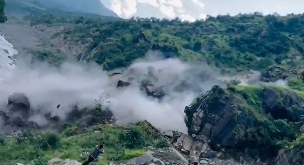
A massive landslide captured on video in the Himalayan region has renewed concerns over the growing vulnerability of mountain communities to extreme rainfall, unstable slopes and the long-term effects of climate change.
Footage shared on October 1 by Surajit Ghosh on X shows a large section of a mountainside in Uttarakhand’s Kumaon region collapsing, sending soil, rocks and debris cascading down the slope. The dramatic visuals have drawn attention to the geological instability of the Himalayan belt, where intense weather events and fragile mountain terrain create conditions for potentially destructive landslides.
The video comes days after another major mountainside collapse in Nepal’s Mustang district, where a section of the mountain plunged into the swollen Kali Gandaki River following heavy rainfall. The incident, filmed and widely circulated on social media, highlighted the scale of erosion and slope failure that can occur in the Himalayan river valleys.
This shocking footage from the Kumaon division in the Himalayan foothills shows a massive landslide in progress, with huge sections of the mountainside collapsing and moving before people’s eyes
What’s happening beneath the Himalayas? pic.twitter.com/bC6Hxb42An
— Surajit (@surajit_ghosh2) October 1, 2026
While the precise trigger and damage associated with the latest Kumaon incident require independent confirmation, the sequence of events underscores the risks confronting one of the world’s most climate-sensitive mountain regions.
Extreme Rainfall and Fragile Himalayan Slopes
The Himalayas are naturally prone to landslides because of their steep terrain, fractured rock formations and ongoing tectonic activity. The Indian and Eurasian plates continue to converge, generating geological stresses that shape the mountain system.
However, increasingly erratic rainfall patterns and rising temperatures are adding to the challenges facing the region. Intense rainfall can rapidly saturate soil, increase pressure within slopes and weaken the natural stability of mountain terrain. When these conditions coincide with already fractured rock or weakened slopes, the likelihood of landslides can increase.
The risks extend beyond individual slope collapses. Whether triggered by the Chinese massive Three Gorges Dam or not, landslides can block rivers, damage roads and bridges, destroy homes and disrupt access to remote settlements. Debris entering river channels can also create temporary blockages that may later collapse, triggering sudden floods downstream.
The September disaster in Nepal illustrates how heavy rainfall can produce multiple hazards simultaneously. Flooding, landslides, river erosion and infrastructure damage can combine to overwhelm local response systems, particularly in remote mountain districts.
Climate change does not independently explain every landslide. Geological conditions, land-use changes, road construction, drainage alterations and the intensity and duration of individual rainfall events also influence the likelihood and severity of slope failures. Establishing the role of climate change in a specific incident requires detailed meteorological and geological investigations.
Warming Himalayas Face Long-Term Climate Threats
The broader climate outlook raises additional concerns for the Himalayan region. Rising temperatures are accelerating changes in glaciers, snow cover and high-altitude hydrology, with consequences for water availability, natural hazards and mountain ecosystems.
Glacier retreat can contribute to the expansion of glacial lakes. Some of these lakes are held back by unstable natural dams made of glacial debris and ice. If a dam fails, a glacial lake outburst flood can send large volumes of water and sediment through downstream valleys with little warning.
Changing precipitation patterns could further complicate the situation. Warmer conditions can alter the balance between snowfall and rainfall, while intense precipitation can increase the risk of floods and landslides. The interaction between glacier melt, extreme rainfall and fragile terrain creates the potential for compound disasters.
India’s Ministry of Earth Sciences has documented a rise of about 0.7 degrees Celsius in the country’s surface air temperature between 1901 and 2018. Its assessment also identifies increasing atmospheric moisture and changes in climatic extremes, including localized heavy rainfall events. The findings point to a changing climate environment in which mountain hazards need to be assessed alongside broader regional warming trends.
For Himalayan states, the consequences are not limited to immediate disaster damage. Repeated disruptions to roads, hydropower infrastructure, tourism and agricultural activity can impose lasting economic costs. Communities dependent on mountain transport corridors are particularly exposed because a single major landslide can isolate settlements and delay emergency assistance.
The challenge for governments is to move beyond emergency response towards sustained risk reduction. This includes more detailed landslide susceptibility mapping, improved rainfall and river monitoring, early-warning systems, safer road construction, better drainage management and restrictions on development in highly vulnerable locations.
The latest footage from Kumaon is a stark reminder of the physical forces shaping the Himalayas. But the larger concern is the growing exposure of people and infrastructure to overlapping geological and climatic hazards. As the region warms and extreme weather risks evolve, the ability to identify vulnerable slopes and prepare communities before disasters strike will become increasingly important.