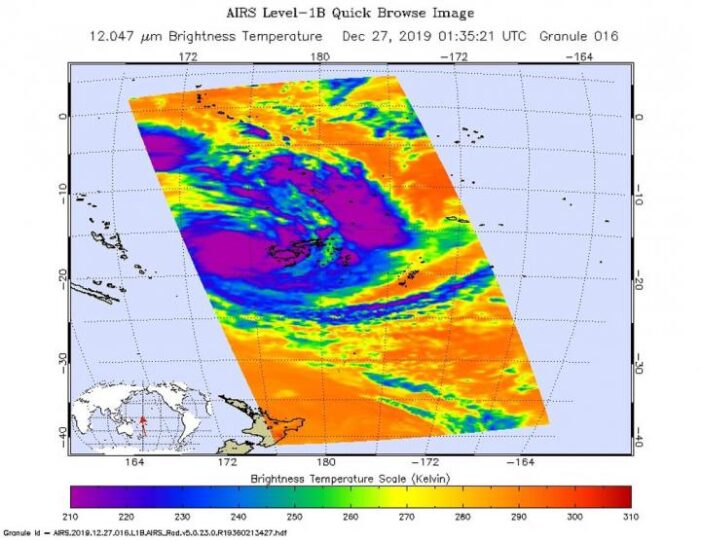
NASA analyzed the cloud top temperatures in Tropical Storm Sarai using infrared light to determine the strength of the storm. Already there are regional warnings in effect for Fiji and Tonga.
In Fiji, there is a storm warning is in force for Vatulele and Kadavu. A gale warning is in force for Vanua Levu, Taveuni, Yasawa and the Mamanuca Group, Kadavu, Lomaiviti Group, Viti Levu and nearby smaller islands. Tonga is on tropical cyclone alert
One of the ways NASA researches tropical cyclones is using infrared data that provides temperature information. Cloud top temperatures identify where the strongest storms are located. The stronger the storms, the higher they extend into the troposphere, and they have the colder cloud temperatures.
On Dec. 27 at 0135 UTC (Dec. 26 at 8:35 p.m. EST) NASA’s Aqua satellite analyzed the storm using the Atmospheric Infrared Sounder or AIRS instrument. The AIRS imagery showed the strongest storms circling the center of circulation, just west of Fiji and in a thick band of thunderstorms northeast of Fiji.
In those areas, AIRS found coldest cloud top temperatures as cold as or colder 210 Kelvin minus 81 degrees Fahrenheit (minus 63.1 degrees Celsius). NASA research has shown that cloud top temperatures that cold indicate strong storms that have the capability to create heavy rain.
Tropical cyclones do not always have uniform strength, and some sides have stronger sides than others, so knowing where the strongest sides of the storms are located helps forecasters. NASA then provides data to tropical cyclone meteorologists so they can incorporate it in their forecasts.
At 10 a.m. EST on Dec.27 the Joint Typhoon Warning Center or JTWC noted that the center of Tropical cyclone Sarai was located near 18.7 degrees south latitude and 176.1 degrees east longitude. That is about 136 nautical miles west-southwest of Suva, Fiji. Maximum sustained winds were near 55 knots (63 mph/102 kph) and the storm was strengthening. It was moving to the south and expected to turn east.
Sarai is forecast to move toward the east. The storm is expected to strengthen briefly to 65 knots on closest approach to the main Fijian islands, but weaken as it nears Tonga.
Typhoons and hurricanes are the most powerful weather event on Earth. NASA’s expertise in space and scientific exploration contributes to essential services provided to the American people by other federal agencies, such as hurricane weather forecasting.
The AIRS instrument is one of six instruments flying on board NASA’s Aqua satellite, launched on May 4, 2002.

