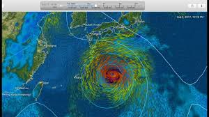
Typhoon Noru was churning just south of the southwestern-most island of Japan when NASA’s Terra satellite captured an image of the storm with an eye over 35 miles wide. The Joint Typhoon Warning Center expects Noru to make landfall in Kyushu by August 6.
On August 4, 2017 at 0220 UTC (Aug. 3 at 10:20 p.m. EDT), NASA’s Terra satellite passed over the Northwestern Pacific Ocean and the Moderate Resolution Imaging Spectroradiometer or MODIS instrument captured a visible-light image of the storm. The image revealed that Noru’s eye had become more apparent since the previous day. The western quadrant of the storm was affecting Japan’s Tokara Islands, which lie to the south of Japan’s large island of Kyushu. The Tokara Islands is an archipelago in the Nansei Islands, part of the Ryukyu Archipelago. The chain of islands consists of twelve small islands between Yakushima and Amami-Oshima.
Animated enhanced infrared satellite imagery and radar imagery indicate that Noru was re-intensifying with improved deep convective thunderstorm banding and a 37-nautical-mile-wide eye.
On August 4, 2017 at 11 a.m. EDT (1500 UTC), Noru’s maximum sustained winds were near 86 mph (75 knots/139 kph). Noru’s eye was centered near 29.3 degrees north latitude and 130.3 degrees east longitude, about 218 nautical miles northeast of Kadena Air Base, Okinawa, Japan. Noru has tracked to the west-northwestward at 5.7 mph (5 knots/9.2 kph).
Warnings are already in effect for the sub-prefecture regions of Kyushu including: Satsuma Chiho, Osumi Chiho, Tanegashima-Yakushima Chiho, Amami Chiho, Nambu Heiyabu, Hokubu Heiyabu, Nambu Yamazoi and Hokubu Yamazoi.
For watches and warnings from the Japan Meteorological Agency on Noru, visit: http://www.jma.go.jp/jma/indexe.html
Noru is forecast to turn north-northeast and make landfall in Kyushu on August 6. The Joint Typhoon Warning Center forecasts the storm will then move in a northeasterly direction and move west of Kyoto on the big island of Japan before moving into the Sea of Japan.

