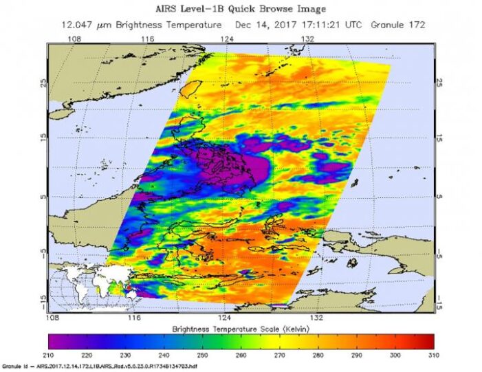
NASA’s Aqua satellite provided infrared imagery of Tropical Storm Kai-Tak that revealed the western side of storm had moved into the southern and central Philippines. Infrared data revealed very cold cloud top temperatures with the potential for heavy rainfall.
The Atmospheric Infrared Sounder aboard NASA’s Aqua satellite captured an infrared image of Tropical Storm Kai-Tak on Dec. 14 at 12:11 p.m. EST (1711 UTC). Infrared data provides cloud top temperatures and the coldest cloud tops and strongest storms were blanketing the southern and central Philippines.
Infrared data showed persistent central cold cover obscuring the low-level circulation center where cloud top temperatures were as cold as minus 115.6 degrees Fahrenheit or minus 82 degrees Celsius. NASA research has shown that storms with cloud tops that cold have the potential to generate heavy rainfall.
On Dec. 15 at 10 a.m. EST (1500 UTC) the Joint Typhoon Warning Center reported that Tropical storm Kai-tak, known as Urduja in the Philippines had maximum sustained winds near 45 knots (52 mph/83 kph). The storm had slowed to a crawl, moving west at just 2 knots (2.3 mph/3.7 kph). When a tropical cyclone slows over land, it increases the likelihood for inland flooding.
Kai-Tak was centered near 11.6 degrees north latitude and 127.6 degrees east longitude, just east of the Eastern Visayas region and about 436 miles east-southeast of Manila, Philippines.
On Dec. 15, the Philippine Atmospheric Geophysical and Astronomical Services Administration (PAGASA) issued Heavy Rainfall Warning No.17 at 8:40 p.m. local time on Friday, December 15, 2017. PAGASA issued orange and yellow level warnings.
There is an Orange Warning Level for Eastern Samar and Samar, where flooding is threatening in low-lying areas and landslides in mountainous areas. There is a Yellow Warning Level for Leyte, Southern Leyte, Biliran, Cebu, Bohol, Siquijor and Negros Oriental where flooding is possible in low-lying areas and landslides in mountainous areas.
The Joint Typhoon Warning Center expects Kai-tak to continue moving westward through the Philippine archipelago, while intensifying slightly. After landfall in the Eastern Visayas region, the storm will weaken and turn to the southwest where it is expected to track into the South China Sea by Dec. 18.
For updated forecasts and warnings from PAGASA, visit: https://www1.pagasa.dost.gov.ph/
Tropical Storm Kai-tak developed near the east central Philippines as the Global Precipitation Measurement mission or GPM core satellite passed overhead and analyzed its rainfall. GPM is a joint mission between NASA and the Japanese space agency JAXA.
The GPM satellite traveled over the Philippine Sea on December 12, 2017 at 7:38 a.m. EST (1238 UTC). The satellite’s GMI and DPR instruments collected data showing that strong convective storms in the area were producing heavy precipitation. GPM’s radar (DPR Ku band) data showed that a few of the most intense storms were dropping rain at a rate of greater than 143 mm (5.6 inches) per hour.
GPM’s radar (DPR Ku band) provided 3-D measurements of precipitation structure within the developing depression in the Philippine Sea. The storms were probed within the 245 km (152 mile) swath scanned by GPM’s Ku band radar. Several of the powerful storms in the area were found by GPM’s radar to reach altitudes greater than 16 km (9.92 miles).
On Dec. 14, Philippines warnings were posted for Tropical depression Kai-tak. Public storm warning signal #2 is in effect for the Visayas provinces of Eastern Samar, Samar, Biliran. Public storm warning signal #1 is in effect for the Luzon provinces of Catanduanes, Camarines Sur, Albay, Sorsogon, Masbate and Romblon; and for the Visayas provinces of Northern Samar, Leyte, and Southern Leyte, Northern Cebu including Bantayan Island, Capiz, Aklan and Northern Iloilo.
On Dec. 14 at 10 a.m. EST (1500 UTC) Tropical Storm Kai-tak, formerly System 96W was located near 11.6 degrees north latitude and 127.6 degrees east longitude, about 433 nautical miles east-southeast of Manila, Philippines. Kai-tak was moving to the west at 2 knots (2.3 mph/3.7 kph), through the central Philippines. Maximum sustained winds were near 35 knots (40 mph/62 kph).
On Dec. 14 at 4:58 a.m. EST (0958 UTC) a Special Sensor Microwave Imager Sounder (SSMIS) image showed a slightly improved organization with strong bands of thunderstorms banding over the northern quadrant wrapping into the southwest quadrant of the system. Animated radar imagery from the Philippine Atmospheric Geophysical and Astronomical Services Administration or PAGASA showed heavy rain bands persisting over the central Philippines.

