
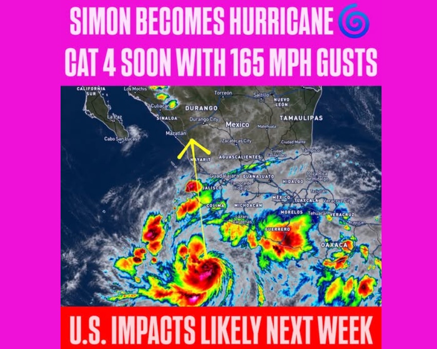
Hurricane Simon intensified into a powerful Category 4 storm off Mexico’s Pacific coast on Saturday, October 10, with forecasters warning of life-threatening flooding, destructive winds and mudslides as it approached a heavily populated stretch of coastline that includes the resort city of Puerto Vallarta.
The National Hurricane Center (NHC) reported maximum sustained winds of 145 mph (233 km/h), making Simon a major hurricane capable of causing severe damage. The storm was expected to approach Mexico’s southwestern and west-central coast late Saturday or early Sunday, while tropical storm-force winds could arrive before landfall.
The immediate threat is compounded by forecasts of 10 to 20 inches (25 to 50 centimetres) of rainfall across parts of southwestern Mexico, with isolated areas potentially receiving up to 30 inches. The NHC warned that the rainfall could trigger life-threatening flooding and mudslides, particularly across steep and mountainous terrain.
Simon is part of an unusual sequence of tropical weather systems affecting North America over a short period. While Simon threatens Mexico, Tropical Storm Rachel is expected to bring rain and gusty winds to California and parts of the southwestern United States. Hurricane Isaias has already made landfall along Florida’s Gulf Coast, bringing flooding and damaging winds.
Hurricane Simon Threatens Puerto Vallarta as Mexico Ramps Up Preparations
Simon’s rapid intensification has raised concerns along Mexico’s Pacific coastline, where coastal communities, fishing towns and tourist destinations face the combined threat of destructive winds, heavy rain and storm surge.
The NHC’s early Saturday advisory placed Simon about 140 miles (225 kilometres) south of Manzanillo and 245 miles (395 kilometres) south-southeast of Cabo Corrientes. The hurricane was moving north at approximately 5 mph (7 km/h), with forecasters expecting it to continue generally northward through the weekend.
A hurricane warning was in effect from Punta San Telmo to Punta Mita along Mexico’s southwestern and west-central coast.
Authorities in Jalisco state suspended classes on Friday and Monday in 22 coastal municipalities and began evacuating residents from vulnerable areas. Officials also instructed tourism operators in Puerto Vallarta to ensure that workers and visitors were accommodated in shelters or other safe locations.
Meteorologist Chris Nunley wrote, “JUST IN: Tropical Storm Rachel is strengthening as it accelerates toward Southern California and northern Baja California Sur! It now has 70 mph wind gusts”

The region’s exposure is significant because Puerto Vallarta is a major international tourist destination, while Manzanillo is one of Mexico’s principal ports and a key gateway for trade with Asia.
AccuWeather meteorologists warned that Simon could produce particularly destructive conditions along the coast. Forecasts included wind gusts of 100 to 120 mph across portions of Jalisco, Nayarit and Sinaloa, with stronger gusts possible in western Jalisco near the storm’s eyewall.
AccuWeather also forecast storm surge of 10 to 15 feet along parts of the Jalisco coastline, potentially adding to coastal flooding and damage.
The storm’s proximity to land could affect its final intensity, but forecasters warned residents not to delay preparations while monitoring changes in its projected track.
Rachel and Isaias Add to Unusual Triple Tropical Threat
Simon’s approach coincides with two other tropical systems, creating a rare concentration of weather hazards across different parts of North America.
In the eastern Pacific, Tropical Storm Rachel was expected to bring heavy rainfall and gusty winds to Southern California and other parts of the southwestern United States over the weekend and into early the following week.
The storm’s interaction with a dip in the jet stream could spread tropical moisture beyond its immediate circulation, increasing the risk of flash flooding and mudslides. AccuWeather also forecast that the moisture could extend into parts of the southwestern United States and eventually reach southern portions of the Plains.
Meanwhile, Hurricane Isaias made landfall near Destin, Florida, on Friday evening as a Category 2 hurricane, with maximum sustained winds of 105 mph. It had briefly strengthened to Category 3 earlier in the week before weakening ahead of landfall.
Although Isaias was expected to lose strength as it moved inland, the threat was not over. AccuWeather warned that heavy rainfall, gusty winds and possible tornadoes could affect areas farther inland over the weekend.
Rainfall forecasts for parts of the southeastern United States ranged from 1 to 4 inches across a broad area, with local totals of 4 to 8 inches and isolated amounts of 8 to 12 inches near the storm’s track. AccuWeather’s maximum local rainfall estimate for Isaias reached 25 inches.
The agency also warned that damaging winds could cause additional power outages well beyond the immediate Gulf Coast.
The three systems illustrate how tropical weather hazards can extend across large geographical areas, with coastal flooding, inland rainfall and damaging winds threatening different communities at the same time.
Why Simon’s Rainfall Could Be More Dangerous Than Its Winds
While Simon’s Category 4 status highlights its destructive wind potential, rainfall poses a major threat in southwestern Mexico.
The region’s mountainous terrain can funnel intense rainfall into valleys and waterways, increasing the risk of flash floods, landslides and mudslides. Such hazards can continue even after the strongest winds subside.
The NHC forecast rainfall totals of 10 to 20 inches across parts of southwestern Mexico, with isolated totals reaching 30 inches. AccuWeather projected that some coastal areas of Jalisco and Colima could receive 18 to 24 inches, with a local maximum estimate of 25 inches.
Simon’s slow movement could also prolong exposure to heavy rainfall in affected areas. Residents in flood-prone locations face risks from rapidly rising water, unstable slopes and roads rendered impassable by debris or flooding.
The NHC urged residents in the warning area to complete preparations to protect life and property and to follow instructions from local authorities.
With Simon approaching the coast and Rachel and Isaias affecting other parts of North America, emergency officials face several simultaneous weather threats. The immediate priority in Mexico is to protect coastal communities and tourists before hurricane conditions arrive, while areas farther north and east prepare for continued rainfall, flooding and damaging winds.