Indian Met Department has issued an alert to Tamil Nadu, Kerala, Karnataka, Goa, Maharasthra and the Lakshadweep over the cyclone ‘Sagar’, which is building up over the Arabian Sea.
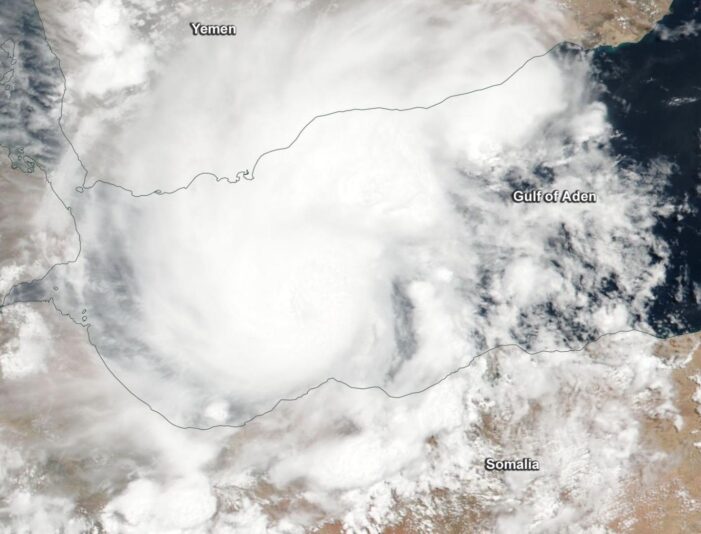
Tropical Cyclone Sagar, formerly known as 01A, captured NASA-NOAA’s Suomi NPP satellite appeared more organized and has been strengthening since May 17. On Friday, May 18 the Visible Infrared Imaging Radiometer Suite (VIIRS) instrument aboard NASA-NOAA’s Suomi NPP satellite captured a true-color image of Tropical Cyclone Sagar that showed the center of circulation in the Gulf of Aden, and the northern and southern quadrants of the storm affecting Yemen and Somalia, respectively.
Cyclone Sagar or 01A quickly formed in the northern Indian Ocean and strengthened into a tropical storm on May 16 at 6:05 p.m. EDT as shown in the moderate resolution imaging spectroradiometer aboard NASA’s Aqua satellite.
The infrared image indicated a small portion of thunderstorms around the center at minus 80 degrees Celsius, indicating very strong storms with a potential for heavy rainfall. It had maximum sustained winds near 46 miles per hour (40 knots), located near 13.0 degrees north latitude and 48.6 degrees east longitude. That’s approximately 229 nautical miles east of Aden, Yemen.
On Friday, at 4 a.m. EDT (1:30 pm IST) Tropical Cyclone Sagar was centered near 11.6 degrees north latitude and 45.9 degrees east longitude, approximately 89 nautical miles southeast of Aden, Yemen. Maximum sustained winds had increased to 69 mph (50 knots/111 kph). Sagar was moving to the west-southwest at 6.9 mph (6 knots/11.1 kph).
Sagar is likely to threaten Yemen, Somalia and Djibouti with waves as high as 17 feet, before hitting the Indian west coast. The Joint Typhoon Warning Center said that Sagar will move southwest through the Gulf of Aden and make a heavy landfall in northwestern Somalia.
The cyclonic storm “#SAGAR” over Gulf of Aden moved further westwards with a speed of 7 kmph during past 6 hours, and lay centered at 2330 hrs IST of 17th May 2018 over Gulf of Aden near latitude 12.80N and longitude 47.50E.#CycloneSagar
Source: IMD
— NDMA India (@ndmaindia) May 18, 2018
Indian Meteorological Department (IMD) has issued an advisory that said: “It is likely to move west-southwestwards and weaken gradually after 12 hours and cross Somalia coast around noon of 19th May 2018, said IMD in a statement.
“Fishermen are advised not to venture into Gulf of Aden and adjoining areas of west-central and south-west Arabian sea. Hoist signal DW-II at all the ports of south and north Gujarat” said the advisory issued by the Met Department. However, Gujarat is not likely to be hit as Sagar weakens by the time it reaches the Kutch coast.
Strong winds reaching upto 75-85 kmph and 95 kmph covering the Gulf of Aden and adjoining south-western Arabian Sea area are very likely duting the next 12 hours. It may then gradually decrease ato 65-75 kmph during the next 12 hours.”

