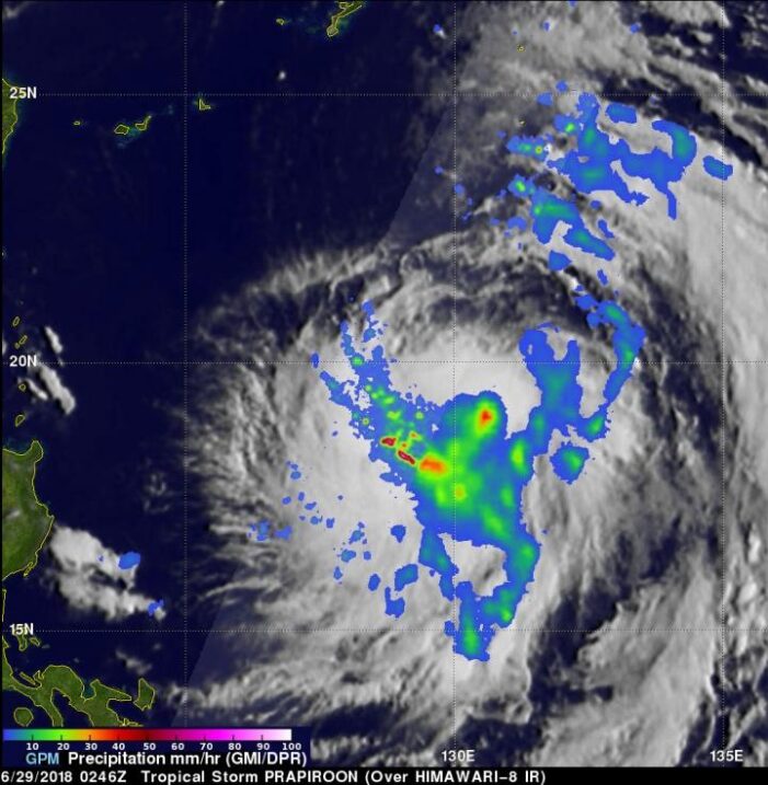
When the Global Precipitation Measurement mission or GPM core satellite passed over the Northwestern Pacific Ocean, it saw very heavy rainfall occurring in one part of Tropical Storm Prapiroon.
Tropical Depression 09W was located east of the Philippines when it was upgraded early today, June 29, to Tropical Storm Prapiroon. The tropical storm is in a favorable environment for intensification. Vertical wind shear is low above the tropical cyclone and sea surface temperatures are warm below.
NASA’s GPM core observatory satellite had a good view of Tropical Storm Prapiroon on June 29, 2018 at 0246 UTC (June 28 at 10:46 p.m. EDT). GPM is a joint mission between NASA and the Japan Aerospace Exploration Agency, JAXA.
At the time GPM passed overhead, Prapiroon was barely a tropical storm with maximum sustained wind speeds estimated at about 35 knots (40.3 mph). GPM’s Microwave Imager (GMI) and Dual-Frequency Precipitation Radar (DPR) instruments measured precipitation around Prapiroon. GPM showed that intensifying the storm was fairly large with its most intense rainfall located in the southern part of the storm. GPM’s radar (DPR Ku Band) scanned convective storms in a feeder band on the southwestern side of the tropical storm where it found that some very intense storms there were dropping rain at a rate of over 192 mm (7.6 inches) per hour.
A 3-D view of Tropical Storm Prapiroon’s precipitation, looking toward the southwest, was created at NASA’s Goddard Space Flight Center in Greenbelt, Maryland, using data captured by GPM’s radar (DPR Ku Band). GPM’s DPR probes provided excellent information about the powerful storms in the large rain band wrapping around Prapiroon’s western side. Storm top heights in that part of the storm were measured by GPM’s radar reaching heights above 12.5 km (7.8 miles).
On June 29 at 11 a.m. EDT (1500 UTC), Prapiroon was centered near 20.0 degrees north latitude and 129.7 degrees east longitude. That’s about 404 nautical miles south-southeast of Kadena Air Base, Okinawa, Japan. The storm is moving to the northwest at 5 knots (5.7 mph/9.2 kph). Maximum sustained winds 45 knots (52 mph/83 kph).
The Joint Typhoon Warning Center (JTWC) predicts that Prapiroon will move toward the north-northwest and intensify into a typhoon on June 30. Prapiroon is expected to continue intensifying and have peak wind speeds of about 75 knots (86 mph/139 kph) as it passes over the East China Sea in a few days.
Prapiroon is predicted by the JTWC to be a minimal typhoon with winds of 65 knots (75 mph/120 kph) as it approaches South Korea on July 2, 2018.

